Community Planning - Cawston
An Official Community Plan (OCP) is the vision a community has for its future. It contains goals and policies that will shape future land use in a way that reflects the community's vision. These goals and policies form a framework used by the Regional Board, Regional District staff, other agencies and the community to guide their decisions about future land use. Should the community of Cawston implement an OCP, it should expect to change and grow in a way that is consistent with the contents of its Plan
At present, the Cawston area (Electoral Area ‘B’) does not have either an OCP or Zoning Bylaw.

Draft Official Community Plan Bylaw
In order to provide residents with an easy way to follow the progress of the Official Community Plan, a Draft version of the Plan is provided below (in .pdf format) and will be updated as the OCP Advisory Committee completes sections:
DRAFT ELECTORAL AREA 'B' OFFICIAL COMMUNITY PLAN BYLAW
Sections completed to date:
1.0 - Interpretation and Administration
2.0 - What is an Official Community Plan?
3.0 - Community Profile
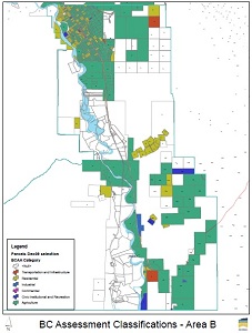
4.0 - Official Community Plan Map Designations
5.0 - Community Vision
6.0 - Broad Goals
7.0 - Growth Management
8.0 - Resource Area
Public Meetings
The next meeting of the Electoral Area 'B' OCP Advisory Committee will be on October 21, 2013 at the Cawston Community Hall from 7-9pm.
MEETINGS:
| 2011 | 2012 | 2013 |
|---|---|---|
| March 22, 2011 (inaugural meeting) | January 17, 2012 Agenda / Minutes | Januaray 15, 2013 |
| April 19, 2011 Agenda / Minutes | February 21, 2012 Agenda / Minutes / Presentation | February 5, 2013 |
| May 17, 2011 Agenda / Minutes | April 17, 2012 Agenda / no quorum | |
| June 21, 2011 Agenda / Minutes | May 15, 2012 Agenda / Minutes | |
| November 22, 2011 Agenda / Minutes | June 19, 2012 Agenda / Minutes | April 15, 2013 |
| December 13, 2011 Agenda / Minutes | November 6, 2012 Agenda / Minutes | May 28, 2013 |
| November 27, 2012 Agenda / no quorum | June 18, 2013 | |
| December 18, 2012 Agenda / Cancelled | October 21, 2013 | |
November 18, 2013 | ||
December 16, 2013 |
Public Open House - April 24, 2013
The Regional District of Okanagan-Similkameen (RDOS) held a Public Meeting in order to provide residents and property owners in Electoral Area ‘B’ (Cawston) with an update on the drafting of an Official Community Plan (OCP). Approximately 50 members of the community attended.
Public Open House - March 13, 2012
A Public Open House was held on March 13, 2012 at the Cawston Community Hall from 6:30pm to 8:30pm (with a presentation at 7:00 pm) in order to present and to receive feedback on a Draft Community Vision Statement and Broad Goals.
Official Community Plan (OCP) Advisory Committee
A total of 15 individuals will provide direction to the Regional District of Okanagan-Similkameen on the suitability of an Official Community Plan (OPC) for the Cawston area.
The OCP Advisory Committee was appointed by the Regional District Board on March 3, 2011, and will assist in identifying the issues facing the community and ensure a draft OCP reflects the community’s ideas and values.
Official Community Plan Advisory Committee Members: Bob Bergen, Celia Bush, George Bush, Tony Dawson, Paul Dhaliwal, Pard Hogeweide, Kevin Klippenstein, Gurpreet Lidder, Al McCormick, Lee McFadyen, Brian Mennell, Lesley Pendleton, Andrea Turner, and Lee Vesper.
OCP Advisory Committee Forum
A Discussion Board, or Forum has been created for the benefit of Advisory Committee Members in order that they may discuss items and post questions between scheduled meetings. While the ability to post to this forum has been restricted to Committee Members, interested community members are able to visit the forum and follow the discussions that are taking place.
Background Material & Reports
Background Statistics - Electoral Area 'B' (2006 Census)
- Land area is approximately 238.75 square kilometres, making Electoral Area 'B' the smallest Electoral Area in the Regional District - representing approximately 2.3% of the total land area;
- Population is 1,082 residents, which represents 1.4% of the total RDOS population.
- Average annual population growth between 1966 and 2006 was 0.97% - which resulted in the population increasing from 735 persons (1966) to 1,082 persons (2006);
- Although the median age has increased from 35 in 1993 to 47.8 in 2006 (versus RDOS average of 49.7), Electoral Area 'B' still has one of the youngest populations in the Regional District with the largest percentage of the population under the age of 15 (17.1% vs RDOS average of 13.5%);
- Single detached houses represent 94.6% of the housing stock in Electoral Area 'B';
- 73.6% of these dwellings were constructed prior to 1986;
- The largest employment sector is "Agriculture and other resource-based industries" at 51.8%.
Reference Material
Legislation:
Local Government Act - Part 26 (Planning and Land Use Management)
Current Land Use Bylaws:
Subdivision Servicing Bylaw No. 2000, 2002
2010 Resident Survey:
Climate Action:
British Columbia Climate Action Charter
RDOS Climate Action Plan (2011)
Bill 27: Opportunities and Strategies for Green Action by BC Local Governments
Sustainable Similkameen Project:
Strategy for a Sustainable Similkameen Valley (2011-2020)
Amenity Migration in the Similkameen Valley - Amenity-led Migration survey: Final Report
Floodplain Mapping:
Similkameen River Dam:
Similkameen Watershed Study (February 2009)
Enloe Dam Project:
Okanogan County PUD - Enloe Dam Project
Provincial Parks (South Okanagan Grasslands Protected Area):
Chopaka East Approved Management Direction Statement
Chopaka West Approved Management Direction Statement
Kilpoola Approved Management Direction Statement
Mt. Kobau Approved Management Direction Statement
Riparian Areas Regulations (RAR):